Some images of the ongoing demolition of Midtown Plaza...
More images and information can be found at Midtown Demolition Images and Midtown Rising
 | ||
| Midtown Plaza from above. Main Street is north. Broad Street is at the bottom of the image. The McCurdy and Euclid buildings are top right, the Citizen's Bank building is top left, Seneca, B. Forman and Wegmans buildings run from north to south along South Clinton Ave, Midtown Tower at center bottom and the Atrium/Town Square is at the center of the complex. The images start at the bottom left corner of this overview and then in a clockwise direction to end up at the bottom right corner. |
 |
| Looking north from Broad Street near the corner of South Clinton Avenue. This is the former site of the Wegmans downtown store. Beyond the Wegmans site the group of buildings that made up the B. Forman department store once stood. The white building in the distance, the Seneca Building, will be partially reused for the Paetec HQ. |
 |
| Looking northeast from the corner of South Clinton and Broad. The Seneca Building on the left already has the curtain wall removed from its South Clinton elevation. The exposed lower columns of the tower are very large as they carry the most weight of the 17 story building's structure. The columns become thinner as the building rises and can be seen in the 12/2009 images provided by the link at the end of this post |
 |
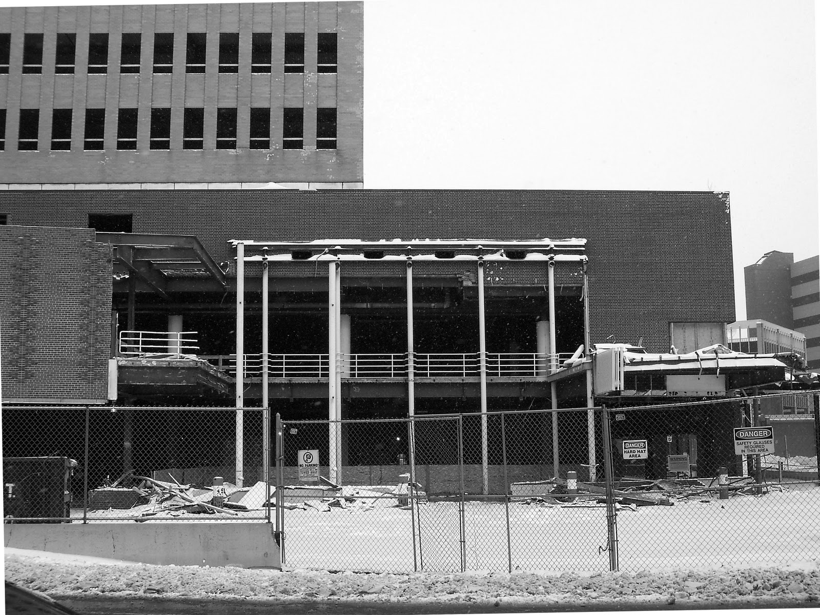
| Looking east/southeast from South Clinton Ave. The B. Forman department store was on the left and the Wegmans grocery store was on the right. The structure of the Atrium is visible. Note the concrete wall at the center of the picture and the section of the cleared site at street level. It denotes where the 1960's mall and underground parking garage begins. The Forman building site is dug down to the basement level because it was there long before Midtown Plaza was conceived and it had no underground parking. |
 |
| This view from the Chase Tower better illustrates the differences between the Forman building's foundation on the left and the street level "roof" of the underground garage on the right. Protecting the garage is very important to the plan so no buildings will be imploded during the redevelopment of the 9 acre site. |
 |
| A straight-on shot of the Atrium structure from South Clinton looking east. The vertical structural members are thicker to the left of the concrete divider than they are to the right. This is likely due to the fact that the section to the left is the terminus of the mall's structure, where it met the 1890's-1920's conglomeration of buildings that made up the B. Forman department store and because the perimeter columns in buildings tend to be more robust. The vertical structural members to the right are thinner as they were interior columns and were not the perimeter of the 1960's mall structure. The Wegmans store would likely have had the thicker columns - seen at left - along its South Clinton elevation's perimeter structure. Images of what the interior of the Atrium looks like are found here. |
 |
| Still a wonderfully scaled and light space, even after losing the trellis suspended from the ceiling. It is likely that half of the Atrium structure - from behind the photographer to the escalators - will be saved as a part of the tower reuse. It would be ideal to reuse the entire Atrium as it is the only spatially and historically valuable structure in the complex, served well for decades as this city of extreme weather's indoor town square and, once unburied from the surrounding structures and filled with natural light, could do so for decades to come. |
 |
| Looking southeast from the corner of South Clinton and East Main Street. From left to right: McCurdy's building, structure of the mall's arcade entrance, the site of the Wendy's and Scheer buildings and the remnants of the Citizen's Bank building at the corner. The Seneca Building still stands along South Clinton. |
 |
| Looking southwest at the Euclid Building from the corner of Atlas and Euclid Streets. |
 |
| Looking east from the 24th floor of the Chase Tower. Note from this view the Atrium's structure jutting out at the point where the B. Forman store's structure ended. The Euclid Building is at center-left in blue. Atlas St. runs in front of the brown high rise at the center on the image. This was the 1960's home of Excellus Blue Cross. They moved to Main Street in the 1980's and then into a gigantic, Fox/Fowle- designed HQ along South Ave in the late 1990's. Non-profit, huh? |
 |
| Looking north from Broad Street at the southeastern edge of Midtown Plaza. To the right is the remnants of the Trailways Bus Lines canopy. The open structure at the center of the image was added after the original complex was completed was a small food court and also served as a Broad Street entrance to the mall. |
More images and information can be found at Midtown Demolition Images and Midtown Rising
I have read so many negative blogs, write ups and articles on city center malls all over North America over the past couple years ive been interested in the subject. How it is such a horrible idea to have a shopping mall downtown, how unfriendly they are to the surrounding city, how the 60's was plagued with urban planning mistakes and how they should all be torn down. Every city center mall who's name I search beings up an article damning it as a planning folly on the cities part and condemning the mall to oblivion in favor of whatever "historic" street grid preceded it no matter how uninteresting or pointless those small streets were.
ReplyDeleteYet I search "Midtown Plaza Rochester New York" And I get nothing but warm memories, nostalgia and theories on what they could have done to reuse and save this mall. Not to mention a heck of alot of pictures of every angle of the complex. It really shows our city had something special. Even though midtown has met its demise through a poorly conceived and unremarkable urban renewal plan, we did alot of things right that resulted in OUR city center mall being remembered as an important and positive part of our cities history. We should be very proud of what we had.
Once: The superblock was the cure for the city's crowded street grid.
ReplyDeleteNow: The city's crowded street grid is the cure for the superblock.
Next: Superblock projects make a comeback in 2060.
Progress!